 Mount Rinjani is the second highest active volcano rises to 3,726 metres (12,224 ft) in Indonesia on the island of Lombok.
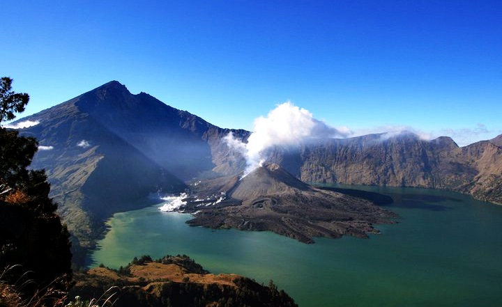
On the top of the volcano is a wide caldera, which is filled partially by the crater lake known as Segara Anak which has a beautiful blue water and estimated to be about 200 metres (660 ft) deep. Religion activities are occasionally done here because the Sasak tribe and Hindu people assume the lake and the mountain Rinjani are sacred places.
MOUNT RINJANI IN LOMBOK ISLAND INDONESIA
Mount Rinjani, Lombok’s highest peak ( 3726 m asl or 12,200 ft. ), draws religious pilgrim and adventure tourist alike. its crater frames a lake, which is 5 miles wide and known as segara anak, which means the lake of child. this crater also contains an active volcano, Gunung Baru
RINJANI NATIONAL PARK The Park Covers an area of 41,330 ha on the northern part of Lombok and locates the three administrative district of West, East and Central Lombok. The area covers 12,357.67 ha in the west, 22,152.88 ha in the east and 6,819.45 ha in central Lombok. Rinjani dominates the National Park of Lombok, an island east of Bali on the Indonesian archipelago. At 3726m it is the second highest volcano in Indonesia, part of the infamous ring of fire that encircles the basin of the Pacific. Within the crater is the spectacular Segara Anak lake and the still – active volcano Gunung Baru (2,363m).
It is surrounded by further 66,000 ha of Protection Forest also covers the three administrative districts. The park ecosystem is in the transitional zone between Asia and Australia (Wallace zone). Average rainfall is about 3,000mm annually.
Mount Rinjani is rich in variety of flora and fauna and vegetation types. There are 114 families and more than 500 several of floras found and about 50 species of plant that can be used for traditional medicine. While fauna in Gunung Rinjani is about 12 mammal and reptile species, more than 50 birds’ species and more 50 several of butterflies which some are protected and has limited area of spread. On the South Western side of mountain is the most eastern extent of primary rainforest in Nusa Tenggara. This gives way to monsoon forest and drier climate in the east, and savannah in the north east. Notable flora includes the everlasting edelweiss flower (Anaphalis viscida), tiger orchid (Vanda sp) alang-alang grass (Imperata cylindrical), cemara tress (Casuarina trifolia and Casuarina ocidentale).
Mount Rinjani, one of the over 50 National Parks through out Indonesia and 21 become National Park model included Mount Rinjani National Park, it was established in 1997. It is valued and protected for its spiritual as well natural values, and is worshipped by thousands of Balinese as well as Sasak pilgrims. Hot springs near the Lake are sought after for their healing powers.
Over 38 villages spread out in 12 sub-districts surround Rinjani and there are many routes up to the mountain, but the main access is from Sembalun Lawang to the East. The challenging three-day Rinjani Trek route from Senaru to crater rim (Pelawangan), down to the stunning crater lake then on to Sembalun Lawang, is considered one of the best treks in South East Asia. Those heading for the summit usually prefer to start in Sembalun Lawang.
The village of Senaru is the main gateway to Mt. Rinjani National Park, the most popular start point for the three day Rinjani Trek up Indonesia’s second highest volcanic peak (3,762 m). For the people of Lombok, Sasak and Balinese alike, the volcano is revered as a sacred place and the abode of Gods. Within the spectacular crater, the Segara Anak Lake is destination of many pilgrims who place offerings in nearby hot spring.
A model for ecotourism in Indonesia, the community-based activities are focused on the Rinjani Trek Centre in Senaru and Rinjani Information Centre in Sembalun Lawang,
the most popular starting points for the tough trek. Developed with New Zealand Government assistance since 1999, the Rinjani Trek Centre and Rinjani Information Centre embody under one roof (satu atap) the unique partnership of the National Park, tourism industry and local communities that has been forged to manage and protect the Rinjani mountain environment. The programmer has been successful and in 2004, the Rinjani Trek won the 2004 Destination Stewardship Award for “the tourism destination that best demonstrates effective protection its natural and cultural environment.”
MOUNT RINJANI TREKKING
Over 38 villages spread out in 12 sub-districts surround Mt. Rinjani and there are many routes up the mountain, but the main access is from Senaru in the north and Sembalun Lawang to the east. The challenging three-day Rinjani Trek route from Senaru to the crater rim (Plawangan), down to the stunning Lake then on to Sembalun Lawang, is considered one of the best treks in South East Asia or the 3-days Rinjani Trek that includes the climb to the Mount Rinjani summit and usually begins in Sembalun Lawang.
A model for ecotourism in Indonesia, the community-based activities are focused on the Rinjani Trek Centre in Senaru and on the Rinjani Information Centre in Sembalun Lawang, the most popular starting point for the tough trek. Developed with New Zealand Government assistance since 1999, the Rinjani Trek Centers embody under one roof (satu atap) the unique partnership of the National Park, tourism industry and local communities that has been forged to manage and protect the Rinjani mountain environment. During the period of the New Zealand Government assistance, the Rinjani Trek Management Board (RTMB) was formed and continues the program of Rinjani Trek Ecotourism Program
Rinjani Trek Ecotourism Program has received the following International and National Awards;
The World Legacy Award sponsored by International Conservation and National Geographic Traveler, June 2004 The Award for Innovative Ecotourism from the Ministry of Tourism, September 2004
A finalist in the Tourism for Tomorrow Destination Awards, April 2005
WHAT YOU MIGHT SEE ON MOUNT RINJANI
Mount Rinjani National Park lies within the major transition zone (Wallaceae) where the flora and fauna of South East Asia makes a dramatic transition into that which is typical of Australasia. The Park has a rich variety of plants and animals, although they can be hard to spot due to the terrain and rainforest cover.
Sometimes seen early in the mornings is the rare black Ebony leaf monkey, known locally as Lutung. The Long tailed grey macaque or Kera is common in Lombok and older males are seen on the crater rim. Rusa deer are forest dwellers and are occasionally seen along the Mt.Rinjani Trek Trail. The smaller Barking deer or Kijang has an alarm call with a distinct dog-like bark. Look for the disturbed ground where the Wild pig or Babi hutan has been foraging. Also found in the forest is the Leopard cat or Bodok alas, Palm civet or Ujat and Porcupine or Landak.
A variety of colourful birds live in the forests of the Park. Perhaps the best-known icon of the Park is the Sulphur Crested Cockatoo that is not found any further west of Lombok. Many of the forest-dwelling animals, insects, birds, civets and monkeys owe their survival to the wild fig tree or Beringin as a provider of food and shelter. The pine-like Casuarina species, Cemara, are a feature of the grassy higher slopes. Orchids or Anggrek are also a feature of the grassland areas, as is Edelweiss or Bunga Abadi growing above the tree line; it is a beautiful icon of the Park and one of our best-known sub-alpine plants.
Mount Rinjani caldera forming eruption is thought to have occurred in the 1257. This eruption is now considered the likely source of high concentrations of sulfur found in widely dispersed ice core samples and may have been the most powerful volcanic blast since humans learned to write.
Rinjani has the most beautiful view of the mountains in Indonesia. Each year the mountain is visited by many tourists from the local, as well as foreign tourists.
Mount Rinjani trekking or hiking Mount Rinjani route can be done via the route from the village Sembalun ,Torean and the route from the village Senaru. Route from Sembalun village is relatively easy and flat but through savanna blazing and the heat will be quite pronounced in the skin. Route from Senaru village is more challenging because it is a continuously hike, but the weather is cool because through the tropical forest.
Trekking Mount Rinjani Information
Exploring Mount Rinjani is a must because this has been included in the Mount Rinjani Lombok Hiking tour Package highlights. It would help if you did not miss the opportunity to visit here. We will provide a more precise explanation for travel and exploration here.
Previously, you experienced a moment when traveling to certain areas was prohibited and restricted. Now it’s free, and you are allowed to visit anywhere you want. Among the many places that can be seen, Lombok must be one of the destinations.
Lombok offers a range of natural destinations. Starting from the exotic hills, mountains, beaches, waterfalls, villages, and traditions, this is the reason why Lombo Island is on the list of the best options to visit. Moreover, everything there is friendly and also attractive.
Lombok promises an everlasting moment during the trip. Among the many vacation spots, maybe what we can provide for you is the exploration of Mount Rinjani. Remember Mount Rinjani, which will be suitable for those of you interested in trekking.
For more details, we will thoroughly explain what you can do while on Rinjani and what this mountain offers. Many years of experience promise a magnificent look, so it’s no wonder that this has become the destination of many people lately.
Mount Rinjani has the status of the second-highest mountain in Indonesia. And automatically, this immediately promises to experience the stunning panorama on Lombok land. If this is your first time hearing about mount Rinjani in Lombok Island highlights, get it now!
Mount Rinjani has a height of 3726 meters. If you reach the top, you will say that you are very proud and have succeeded in creating memories that will never be forgotten. This is because up there, you will be rewarded with stunning views, and that’s what we all love!
However, conquering this mountain is challenging. Getting a more definitive guide and explanation regarding this mountain would be best. So that later, the choice to hike Mount Rinjani will not make you regret it; instead, it will be a positive experience to remember.
How to climb Mount Rinjani?

If you need up-to-date information about climbing Mount Rinjani, please read our official Mount Rinjani Trekking Guide. In short, the most direct route to Mt Rinjani’s summit is from the Sembalun side. Most ascents are usually made in the early morning. Although the mountain is not technically difficult, it is recommended to use a registered trekking company to climb Mount Rinjani. Many people choose to climb Mt Rinjani as a circuit, starting in Senaru and descending down to the crater lake, before climbing to the summit on the final day. You can climb Mt Rinjani as part of a 2 day/ 1 night; 3 day/ 2 night or 4 day/ 3 night package. Should you just want to climb as far as the mount rinjani crater rim (an achievement in itself) it is possible to do this as part of a 2 days 1 nights trek to mount rinjani Crater Rim senaru trek.
When did Mount Rinjani last erupt?
Mount Rinjani last erupted on 27th September 2016. A small-scale eruption of Mt Barujari (which sits in Lake Segara Anak) produced a plume of ash that rose 2km above the crater, disrupting air travel in the region. No one was killed or injured as a result of the eruption.
Where is Rinjani Mountain?
Rinjani Mountain is located on the island of Lombok in Indonesia. Lombok is situated in South East Asia, and forms part of the Lesser Sunda Isles. Mount Rinjani’s geographical co-ordinates are 8°24′52″S 116°27′35″E. Technically Mt Rinjani is in North Lombok (it falls under the administration of the Regency of North Lombok), but the slopes of Gunung Rinjani National Park span to North, East, West and Central Lombok – the mountain very much dominates the island.
How high is Lombok Volcano?
The summit of Mount Rinjani is 3726m / 12,224ft elevation (AMSL).
How was Mount Rinjani formed?
The volcanic activity that formed Mount Rinjani is due to the subduction of the Indo-Australian oceanic crust beneath the Lesser Sunda Islands (an archipelago of which Lombok is part). In its current form, Mt Rinjani and its large crater lake are thought to have formed when Mt Samalas erupted in 1257. This eruption was colossal in scale, and is believed to have contributed to a period of global cooling and mini ice age. Mt Barujari (which sits in the crater lake, Segara Anak) is the active part of this historic volcanic system. It is believed by geologists that Mt Samalas stood next to Mt Rinjani. If you imagine the slopes that lead up to the caldera continuing to a summit, you can speculate as to where Samalas stood, and how high. It is believed that pressure in a magma chamber beneath Samalas rose to such a point that it started cracking the rock above it. When the magma broke out of Samalas the chamber below it partially emptied. With nothing to support the great weight of Mt Samalas above, the mountain collapsed in on itself. At its peak the eruption of Samalas blasted out over one million tonnes of material a second. During the ultimate collapse of the mountain, six cubic miles of ash and volcanic rock formed giant pyroclastic flows that raced down towards the coast at speeds of over 125 miles per hour. An immense volcanic cloud started to envelop the whole world. This was a cataclysmic event that is thought to be greater in magnitude than the eruption of Krakatoa.
What type of volcano is Mount Rinjani?
Mount Rinjani a stratovolcano, a volcano built-up of alternate layers of lava and ash. Stratovolcanoes are typically found along subduction zones (areas where one tectonic plate is pushed beneath another tectonic plate into the Earth’s Mantle). Mount Rinjani is also classed as a somma volcano, “a volcanic caldera that has been partially filled by a new central cone” (in this case the active Mt Barujari).
Is Rinjani Mountain dangerous?
Compared to many mountains around the world, Mount Rinjani is fairly safe to climb. It is not a technical mountain, with the paths well established and easy to follow. Although there are some steep sections where you should exercise caution, the use of ropes is not necessary. The main routes are trekked by thousands of tourists a year, many of whom are not experienced mountaineers. Volcanically Mt Rinjani is active, but the active component (Mt Barujari) lies in the lake, away from the trail. If agencies detect signs of increased volcanic activity that may result in an eruption, they take the precautionary measure of closing the National Park. Lombok is susceptible to earthquakes, which can result in rocks getting dislodged and landslides occurring. When this occurred in 2018 the mountain was evacuated successfully and the park temporarily closed. Fatalities are not completely unheard of, but thankfully they are very rare. The most prominent case of people losing their lives on the mountain was in 2007, when 7 students died from exposure. The university students had embarked on the ill-fated expedition despite all trekking routes in the national park being closed due to inclement weather. For this and other reasons, Adi Trekker Tour & Travel always follows the rules of TNGR, the national park authority.
How hard is Hike To volcano?
How hard you will find climbing Mount Rinjani will depend on your fitness level and hiking experience. The distances covered each day are not great (typically 10-14km), but there is significant elevation gain (which translates as steep hills!). The climb to the summit is difficult, as it involves steep gradient and soft terrain, but you don’t have to be a superhuman athlete to climb Mount Rinjani – we have had customers of all ages and levels conquer this amazing peak. To help people prepare for the challenge of climbing Mount Rinjani we created a fitness guide and video resource on our YouTube channel. You can find our exercise series, Mount Rinjani Training Guide here.
What to pack for a Mt Rinjani Trek?
You can find a comprehensive Rinjani packing list in the official Mount Rinjani Trekking Tour Guide which is published by Adi Trekker every year. In short, Adi Trekker provides all camping and cooking equipment necessary for a Mt Rinjani trekking package. This is carried by our guides and porters. Most customers can fit all they need into a daypack of around 30-40l capacity. How many clothes you pack will depend on which Rinjani Hiking package you are doing. You should take enough clothes for the number of days you are trekking for. We can lend jackets, hats, gloves, trekking poles, and other essential items.
What to wear on Mount Rinjani Tour?
For a complete packing-list and further information about climbing Mount Rinjani, please refer to our official Mount Rinjani Trekking Guide, which is updated frequently and serves as the most comprehensive resource for people wanting to summit Rinjani. In short, Lombok is situated in the tropics, so daytime temperatures are usually warm. T-shirt, shorts and trekking shoes are recommended for daytime walking. At night-time temperatures can drop significantly, so warm layers, trousers and a jacket are necessary. Going to the summit in the early morning can be particularly cold, especially if it is windy. In addition to the warm clothes already mentioned, hat and gloves are highly recommended. Being in the tropics there is also the chance of heavy rain. Rain can either be a quick shower or a prolonged torrent. For that reason, it’s worth taking a rain jacket or poncho. Please refer to our frequently asked questions for more in-depth advice about clothing and equipment.
*NOTES
When you book your mt rinjani trek through Adi Trekker Trekking Company, you will be provided with English Speaking Mountain Guide and local porters and most of the camping essentials such as tent, sleeping bags, mattress, cooking set. etc
However, our mountain guide and porters are in charged only to carry all camping equipments (tents, sleeping bags, mattresses, etc), cooking set and logistics needed during the program (food, water, snacks, fruits, soft drink, etc) they are not in charge to carry your personal belongings.
If you need extra porters to carry your personal stuffs, they are available at extra cost of USD 25 per porter per day. You are advised to travel as light as it could be, the rest of your luggage can be stored at our office. and get them back after the trek.
Bellow are list of items you should carry during the trek programme. All items to be packed in a small backpack no more than 5 kgs.
Torch or Flashlight
Toiletries
Sun block/lotion, hat/cap, sun glasses
Spray for muscle/balm
Insect repellent
Camera, Handicam (Manual or Digital)
Extra rolls film for manual camera or fully charged extra battery for digital camera
Small towel
2/3 pcs of T-Shirts
Long trek pants/wind proof
Windproof Jacket
2 pcs of shorts
Trek stick/lekki (optional)
Sandals (optional)
Swimming Suite (optional)
Binocular (optional)
Extra trail snack (we supply fruits,menu)
Fishing Gear (optional)
Gloves
Garbage Plastic can (optional)
Your luggage can be storage at our office during the trek program
Bring only what you need, the rest leave them in our office.